
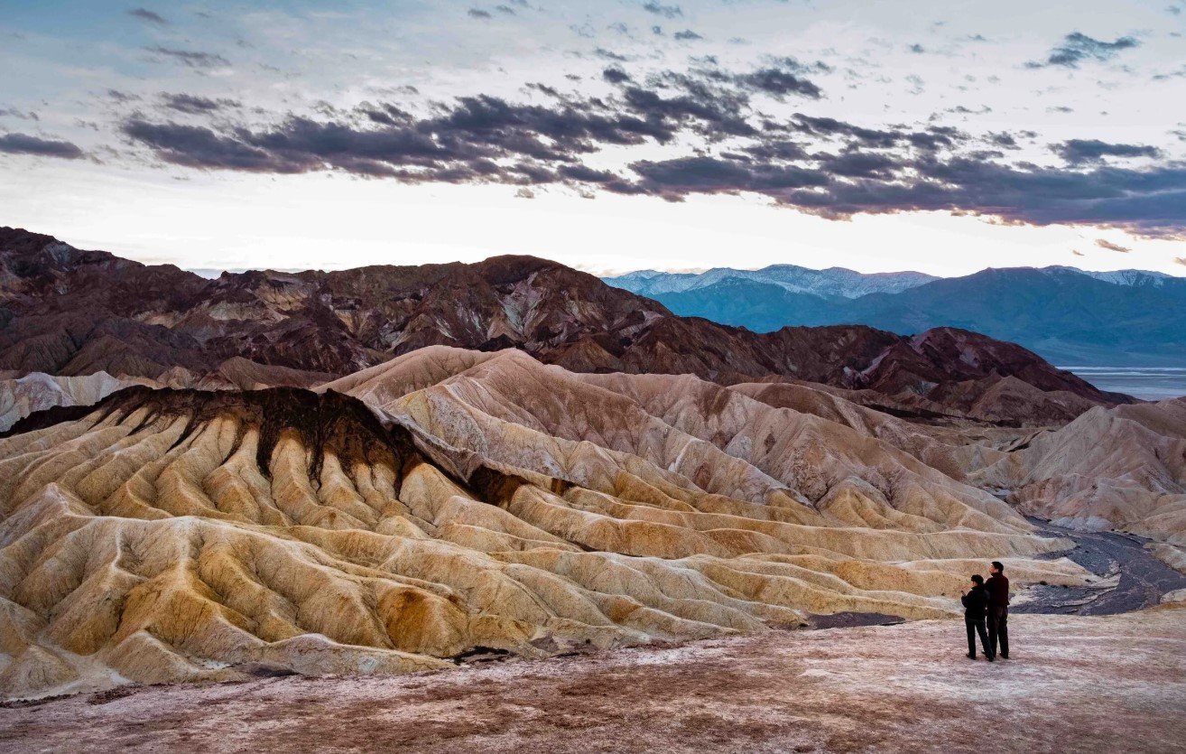
Death Valley is one of North America’s most distinctive valleys, known for its extreme elevation, intense desert climate, salt flats, rugged mountains, and unusual geological formations. Located primarily in eastern California near the Nevada border, the valley forms the geographic heart of Death Valley National Park and contains landscapes ranging from below-sea-level salt pans to high mountain peaks.
The valley is especially notable for the contrast between its lowest and highest terrain. Badwater Basin reaches 282 feet (86 meters) below sea level, while Telescope Peak rises to 11,049 feet (3,368 meters) in the nearby Panamint Range. This dramatic change in elevation helps create the valley’s unusual climate, ecosystems, and scenery.
Today, the area attracts visitors interested in desert landscapes, geology, hiking, photography, wildlife, history, and dark-sky viewing. Its story also includes the long presence of the Timbisha Shoshone, nineteenth-century mining, the famous Twenty Mule Team borax operations, and the development of Death Valley as a protected national park landscape.
Death Valley Quick Facts
| Fact | Details |
|---|---|
| Valley | Death Valley |
| Location | Eastern California, near the California-Nevada border |
| Country | United States |
| Region | Mojave Desert / Basin and Range |
| Lowest Elevation | 282 ft (86 m) below sea level at Badwater Basin |
| Highest Nearby Peak | Telescope Peak, 11,049 ft (3,368 m) |
| Main Water Feature | Badwater Basin; historic Lake Manly |
| Famous For | Extreme heat, salt flats, desert geology and below-sea-level terrain |
| Climate | Extremely hot and arid desert |
| Best Months | Generally October through April |
| Nearby Cities/Towns | Furnace Creek, Beatty, Pahrump, Lone Pine and Shoshone |
Where Is Death Valley?
Death Valley is in eastern California, close to the Nevada state line. The valley lies within Death Valley National Park, a huge protected area that extends across southeastern California and includes a small section of Nevada. The valley trends generally northeast to southwest between the Amargosa Range on the east and the Panamint Range on the west.
The main visitor hub is Furnace Creek, which is located near the center of the park’s developed facilities. Other important access and service areas include Stovepipe Wells and Panamint Springs. Communities outside the park, including Beatty and Pahrump in Nevada and Lone Pine and Shoshone in California, are also useful starting points for different approaches.
For travelers coming from a major metropolitan area, Las Vegas is one of the most common gateways. The park is roughly a two-hour drive west of Las Vegas under normal conditions, although actual travel time depends on the entrance and destination within the park.
Geography and Landscape
Death Valley is a long, narrow desert basin surrounded by mountain ranges. The valley itself is about 140 miles long, while the broader Death Valley National Park covers roughly 3.4 million acres. The surrounding landscape includes steep mountain slopes, alluvial fans, salt flats, dry lakebeds, dunes, badlands, canyons, volcanic formations, and high mountain environments.
One of its defining physical characteristics is the enormous difference in elevation across a relatively compact region. Badwater Basin sits 282 feet below sea level, while Telescope Peak reaches 11,049 feet. The two locations are separated by only about 15 miles, creating one of the most dramatic elevation contrasts in the region.
The valley floor contains extensive salt deposits left behind by evaporation. Badwater Basin’s salt flats cover nearly 200 square miles and contain minerals including sodium chloride, calcite, gypsum, and borax. The Devils Golf Course farther north is another striking salt landscape, where wind, rain, and occasional flooding have sculpted the salt into sharp, irregular formations.
Sand dunes are another important landscape feature. At Mesquite Flat Sand Dunes, mountains provide a source of eroding sediment while surrounding terrain helps trap windblown sand, allowing a substantial dune field to develop. The area contains crescent, linear, and star-shaped dunes.
History of Death Valley
The human history of Death Valley extends far beyond the mining era. The Timbisha Shoshone have lived in the region for centuries, relying on seasonal resources including pinyon pine nuts and mesquite beans. The landscape also contains places of cultural importance to the tribe.
The valley gained its English name during the winter of 1849–1850, when a group of pioneers attempting to reach California became lost in the region. Although only one member of the group is known to have died in the valley, the experience contributed to its ominous name. The story of the Lost ’49ers subsequently became part of the area’s western history.
Mining became a major influence during the late nineteenth and early twentieth centuries. Gold, silver, borax, and other minerals attracted prospectors and entrepreneurs. The Harmony Borax Works near Furnace Creek operated from about 1883 to 1888 and became particularly famous for its large Twenty Mule Team wagons, which transported borax across difficult desert routes toward the railhead at Mojave.
Chinese workers also played an important role in the area’s mining history. NPS records document Chinese laborers working at Harmony Borax Works and elsewhere in the region. Mining communities later appeared around gold and silver operations, although many of the boom towns declined as mining opportunities changed.
Tourism gradually became another part of Death Valley’s story. The area’s distinctive scenery, historic sites, and extreme environment attracted visitors, while conservation efforts eventually helped protect the valley’s natural and cultural resources as part of the national park system.
How Was Death Valley Formed?
Death Valley’s formation is the result of several geological processes rather than one single event. The region belongs to the Basin and Range Province, where extension of Earth’s crust caused mountain ranges to rise while adjacent basins dropped along faults. In Death Valley, this tectonic activity has continued to shape the landscape over millions of years.
Faulting is particularly important to the valley’s extreme elevation. The Death Valley region contains a complex system of strike-slip and normal faults that has allowed the basin to sink while surrounding mountains rise. This geological process helped produce the exceptionally low Badwater Basin.
Water has also played a major role. Although Death Valley is extremely dry today, the basin has experienced periods when large lakes occupied parts of the valley. Ancient Lake Manly existed during multiple periods, and later climatic changes transformed the lake environment into the dry landscape seen today. Floodwater continues to reshape washes, canyons, alluvial fans, and salt deposits.
The region also contains volcanic features. Ubehebe Crater, for example, formed when rising magma encountered groundwater and generated a steam explosion. The resulting maar crater is approximately 0.5 miles wide and is estimated to be about 2,100 years old.
Death Valley Weather Throughout the Year
Death Valley weather is defined by extreme heat, very low precipitation, strong seasonal contrasts, and major differences between the valley floor and surrounding mountains. Furnace Creek, one of the principal climate reference locations, has recorded some of the world’s most extreme temperatures. The highest recorded air temperature there was 134°F (57°C) on July 10, 1913.
Average annual precipitation is only around two inches or less in the low valley. NOAA’s 1991–2020 normal precipitation for Death Valley is approximately 2.20 inches, while the National Park Service reports an average close to 1.94 inches in its Furnace Creek climate summary.
January to March: Cool Winter and Early Spring
January is one of the coolest periods in the valley, with Furnace Creek’s long-term average high around 67°F (19°C) and average low around 40°F (4°C). February and March become progressively warmer, with average highs of about 73°F (23°C) and 82°F (27°C), respectively.
Rain remains limited, although winter storms can occasionally bring precipitation. Higher elevations can be substantially colder than the valley floor and may receive snow. Early spring is also a popular period for exploring the lower elevations before summer heat becomes severe.
April to June: Rapidly Increasing Heat
Temperatures rise quickly during spring. Average highs at Furnace Creek are about 90°F (32°C) in April, 100°F (38°C) in May, and 110°F (43°C) in June. Average nighttime temperatures also climb from approximately 62°F (17°C) in April to 81°F (27°C) in June.
April can still provide comfortable conditions for hiking and sightseeing, while May and June become increasingly challenging in exposed low-elevation areas. Spring winds are also common in the desert.
July to September: Extreme Summer Heat
Summer is the most demanding season in Death Valley. Furnace Creek’s average high reaches approximately 116°F (47°C) in July and remains around 115°F (46°C) in August before falling to about 106°F (41°C) in September. Average lows remain exceptionally high, ranging from roughly 88°F (31°C) in July to 76°F (24°C) in September.
Temperatures can exceed 120°F (49°C), and even nighttime conditions may remain dangerously hot. Late-summer thunderstorms can also occur, bringing the risk of flash flooding despite the valley’s overall dryness.
October to December: Cooling Desert Conditions
Temperatures begin to decline noticeably in October. Furnace Creek’s average high is about 93°F (34°C) in October, 77°F (25°C) in November, and 65°F (18°C) in December. Average lows fall from about 61°F (16°C) in October to 38°F (3°C) in December.
This transition makes late autumn and early winter much more comfortable for sightseeing and outdoor activities at lower elevations. Winter storms remain possible, particularly in the mountains.
Best Weather for Visiting Death Valley
For most visitors, October through April offers the most practical weather for exploring Death Valley. Spring is especially popular because temperatures are generally manageable and seasonal wildflowers can add color to the desert when conditions are favorable. Winter provides cool daytime temperatures and striking views of snow on the higher mountains.
Summer is considerably more difficult for hiking and extended outdoor activity at low elevations because of extreme heat. Visitors who travel during the hottest months need to plan around the conditions rather than treating the valley like a conventional warm-weather destination.
Things to Do in Death Valley
Explore the Salt Flats
Walking around the accessible areas of Badwater Basin is one of the classic Death Valley experiences. The broad salt landscape provides a close look at the minerals and patterns created by evaporation and changing water levels. Visitors should avoid long walks during extreme heat.
Hike Through Desert Canyons
Death Valley has hiking routes ranging from short walks to strenuous mountain climbs. Golden Canyon, Natural Bridge, and other canyon environments allow visitors to see how occasional rainfall and flash floods have carved through desert rock and sediment.
Walk the Mesquite Flat Sand Dunes
The Mesquite Flat Sand Dunes offer an easy-to-reach landscape for walking, photography, and exploring. There is no formal trail to the tallest dune, so visitors navigate across the sand themselves. NPS advises against hiking the dunes after 10 a.m. during summer because of the extreme heat.
Enjoy Scenic Drives
Several roads provide access to Death Valley’s major landscapes. Artists Drive is particularly popular for viewing colorful hills and geological formations, while Badwater Road connects several important attractions on the valley floor.
Photograph Sunrise and Sunset
The valley’s wide-open terrain, mountains, dunes, and salt formations provide numerous opportunities for landscape photography. Zabriskie Point is especially well known for sunrise and sunset views over the badlands.
Experience the Night Sky
The combination of extremely dry air, limited development, and broad areas of undeveloped desert makes Death Valley an excellent setting for stargazing. Visitors can explore the night sky from places such as the Mesquite Flat Sand Dunes and other open areas, while winter ranger programs may also be available.
Explore the Valley’s History
Historic mining sites, Harmony Borax Works, old townsites, and cultural landscapes provide opportunities to understand how people lived and worked in this difficult environment.
Famous Attractions in and Around Death Valley
Badwater Basin
Badwater Basin is the lowest point in North America at 282 feet below sea level. Its enormous salt flats form one of the most recognizable landscapes in the valley.
Zabriskie Point
Zabriskie Point overlooks the colorful badlands near Furnace Creek. Water erosion created the layered hills, while the elevated viewpoint provides broad views toward the salt flats and Panamint Range.
Mesquite Flat Sand Dunes
Located near Stovepipe Wells, these dunes are among the easiest major dune fields in the park to reach. Their shifting patterns, mesquite vegetation, and dramatic evening shadows make them a favorite photography location.
Dante’s View
Dante’s View sits high above Badwater Basin on the Black Mountains and provides an expansive perspective across the salt flats toward the Panamint Range. The viewpoint rises more than 5,500 feet above Badwater Basin.
Artists Drive and Artists Palette
Artists Drive is a one-way scenic road through colorful volcanic and sedimentary hills. Artists Palette, along the route, is particularly notable for its range of mineral-related colors.
Devils Golf Course
This enormous salt landscape is characterized by sharp, irregular salt formations created through evaporation, wind, rain, and occasional flooding. The terrain looks dramatically different from the smooth salt flats at Badwater Basin.
Ubehebe Crater
Ubehebe Crater is a large maar volcano in northern Death Valley. Its steep walls and surrounding volcanic landscape provide a striking example of explosive volcanic activity in the region.
Harmony Borax Works
The preserved Harmony Borax Works site offers a direct connection to Death Valley’s mining era. Interpretive displays explain borax processing and the famous Twenty Mule Team transportation system.
Natural Bridge
Natural Bridge is a short canyon hike leading to a rock formation created by erosion and flash-flood processes. Unlike the smooth sandstone arches found in parts of Utah, the Death Valley formation consists largely of cemented alluvial material.
Scotty’s Castle
Scotty’s Castle, formally known as Death Valley Ranch, is a historic property associated with Albert Johnson and the colorful character Walter “Death Valley Scotty.” The site remains under restoration following major flood and fire damage, and access is currently restricted rather than being a normal open attraction.
Wildlife and Nature
Despite its severe climate, Death Valley supports a surprisingly varied ecosystem. Plants and animals have evolved specialized ways to survive extreme heat, scarce water, salty soils, and large differences in elevation. The park includes environments ranging from salt flats and desert valleys to cooler mountain habitats.
Desert bighorn sheep are among the area’s notable mammals and can occur throughout the valley and surrounding mountains, usually near water sources. Coyotes, kit foxes, bobcats, gray foxes, badgers, ringtails, mule deer, and other mammals are also recorded in the park.
The Salt Creek area provides habitat for the Salt Creek pupfish, a small fish adapted to the harsh desert environment. The seasonal flow at Salt Creek is particularly important during cooler months, and spring is a notable period for observing pupfish spawning behavior.
Vegetation changes significantly with elevation and available water. Mesquite grows in suitable lowland environments, while higher mountain areas support different plant communities. Seasonal wildflowers can appear after favorable winter and spring rainfall, although blooms vary considerably from year to year.
How to Reach Death Valley
Most visitors reach Death Valley by private vehicle or an organized tour because there is no public transportation to or within the national park. The park has multiple paved entrances, making it possible to approach from both California and Nevada.
Major paved approaches include California Highway 190 from Death Valley Junction, California, and from the Olancha area; routes from Shoshone and Trona; and Nevada approaches from Beatty and U.S. Route 95. The best entrance depends on where you are coming from and which part of the park you plan to explore.
Las Vegas is a major gateway for travelers approaching from Nevada. From California, Lone Pine, Olancha, Shoshone, and Death Valley Junction can serve as useful approach points depending on the route.
There are also numerous unpaved roads, but these require more planning and may be unsuitable for ordinary vehicles. Road conditions can change because of flash floods, storms, and washouts, so visitors should check current conditions before departure. Cell service is unavailable across much of the park, making offline maps and adequate supplies particularly important.
Where to Stay Near Death Valley
Because Death Valley is exceptionally large, choosing accommodation based on the areas you want to explore can reduce unnecessary driving.
Furnace Creek is the main developed visitor area and offers the greatest concentration of lodging and visitor services. The Oasis at Death Valley includes The Inn at Death Valley and The Ranch at Death Valley, providing different accommodation styles in the Furnace Creek area.
Stovepipe Wells is another practical base, particularly for visitors focusing on the Mesquite Flat Sand Dunes and northern or central park attractions. Stovepipe Wells Village provides lodging, food, fuel, and other visitor services.
Panamint Springs is located toward the western side of the park and offers lodging, camping, food, and fuel. It can be convenient for visitors approaching from the western side or planning to explore the Panamint Valley and western sections.
Camping is also available, ranging from developed campgrounds to more primitive sites. Furnace Creek Campground offers reservations during its main camping season, while other campgrounds operate on a seasonal or first-come basis. Conditions and campground availability can change, so current park information should be checked before arrival.
Why Is Death Valley Famous?
Death Valley is famous for the combination of extremes found within a single landscape. It contains North America’s lowest point at Badwater Basin, some of the world’s most extreme recorded heat, exceptionally low rainfall, vast salt flats, rugged mountain ranges, sand dunes, colorful badlands, and unusual volcanic formations.
Its reputation also comes from its human history, including the Lost ’49ers, Timbisha Shoshone heritage, mining camps, borax production, and the iconic Twenty Mule Team. Together, these natural and cultural characteristics make Death Valley one of the most distinctive desert valleys in the United States.
Death Valley FAQs
Where is Death Valley located?
Death Valley is primarily in eastern California near the Nevada border. It lies within Death Valley National Park, which also extends into a small part of Nevada.
What is Death Valley famous for?
It is best known for its extreme heat, extremely dry climate, Badwater Basin, salt flats, dramatic desert mountains, unusual geology, and mining history.
What is the weather like in Death Valley?
The climate is extremely hot and dry, particularly from late spring through early autumn. Winter and spring are much cooler, while summer temperatures can exceed 120°F (49°C).
What is the best month to visit Death Valley?
There is no single best month for everyone, but the cooler period from roughly October through April generally provides the most comfortable conditions for sightseeing and outdoor activities.
What can you do in Death Valley?
Popular activities include hiking, scenic driving, photography, exploring salt flats and dunes, visiting historic sites, wildlife watching, and stargazing.
How do you reach Death Valley?
Most visitors drive because there is no public transportation into or within the park. Major paved approaches connect the area with California and Nevada.
How low is Death Valley?
Badwater Basin reaches 282 feet (86 meters) below sea level, making it the lowest point in North America.
Does Death Valley get snow?
Snow is uncommon on the valley floor but can occur in the surrounding mountains, where elevations are much higher and temperatures are considerably colder.
What attractions are near Death Valley?
Major attractions include Badwater Basin, Zabriskie Point, Mesquite Flat Sand Dunes, Dante’s View, Artists Drive, Devils Golf Course, Ubehebe Crater, Harmony Borax Works, and Natural Bridge.
Final Thoughts
Death Valley stands apart because its identity comes from extremes rather than a single landmark. Below-sea-level salt flats, towering mountains, ancient lake deposits, volcanic features, desert wildlife, and a complex human history all exist within the same vast landscape.
For travelers who enjoy geology, photography, hiking, history, wildlife, scenic drives, and exceptionally dark night skies, Death Valley offers a remarkably varied experience. The cooler months are generally the most practical time to explore its lower elevations, while every season reveals a different side of this extraordinary desert valley.
For More Visit ValleyTaxNV
